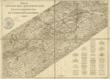
 Nástin geologické mapy středočeského siluru Nástin geologické mapy středočeského siluru(Geological sketch map of central Bohemian Silurian ) Authors: Krejčí, Jan; Feistmantel, Karel Author's comment: Lithography Farský, Prague Country: Czech Republic; Czech Crownlands Document language: Czech, German Publisher: Fr. Řivnáč (commission publisher), Prague, first edition Supplement to a paper: Orograph.-geotekt.Übersicht des Silur.Gebietes im mittleren Böhmen, published concurrently in Czech and German versions in collection "Archiv pro přírodovědecký výzkum Čech/Archive for scientific research of Bohemia / Archiv für die naturwissenschaftliche Durchforschung von Böhmen", Part V/5 Year: 1885 Scale: 1 : 288 000 Theme of the map: geological map without Quaternary deposits Type: Map Color: Coloured Form: Bound appendix Kind: Printed Original source for this digital copy : Czech Geological Survey, Prague , Czech Geological Survey, Prague Original dimensions: 246 x 336 mm (height x width) |
| Other variety of this document |


