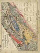
 Nástin geologické mapy středočeského siluru Nástin geologické mapy středočeského siluru(Geological sketch map of central Bohemian Silurian ) Author: Krejčí, Jan Author's comment: Lithography Farský, Prague Country: Czech Republic; Czech Crownlands Document language: Czech, German Publisher: b.v., b.m. Coloured version of topographic map surprint with handwritten legend columns. Presumably holograph by J.Krejčí for printing of map supplement, which is different in its printed form (arrangment of legend columns) Year: Scale: 1 : 288 000 Theme of the map: geological map without Quaternary deposits Type: Map Color: Coloured Form: Loose map Kind: manuscript Original source for this digital copy : Czech Geological Survey, Prague Original dimensions: 246 x 336 mm (height x width) |
| Other variety of this document |


