|
|

Financed by the EEA and Norway Grants 2009-2014
|
|
About project
|
Objectives of the project:
- Access the data of long-term monitoring (GEOMON) for needs of scientific and academic organisations and government.
- Complete the database of catchments with the objectively measured data on supply of ecologically important elements in soils and biomass
- With the help of evaluation of the relationship between the water quality and the biodiversity of phytobentos (algae) estimate the future ecological conditions of headwater areas on the base of the evolution of surface water chemistry.
- Fulfil the obligations during the environment conditions monitoring resulting from the membership of CR in the international agreements about the environment protection (LRTAP- the Convention on Long-Range Transboundary Air Pollution).
- Help to define the criteria for running water and forest soils protection, useable for preparation of national legislation within the adaptation of European directives (Water Framework Directive, Soil Framework Directive).
|
GEOMON
The network of small forest catchments (GEOMON – GEOchemical MONitoring) was established in 1994 and it works without an interruption till today. Thanks to the GEOMON data we can assess time changes in the composition of all three basic components (precipitation, soil, and runoff) that involve the function of ecosystems (biodiversity, sustainable productivity). Nowadays, we have the data from 20 years of continuous monitoring of mass balance of ecologically important elements in monthly/weekly accruals. Obtained data serve to detailed and qualified calibrations of biogeochemistry and hydrological models simulating the impacts of climate changes, chemical composition of precipitation and the management of landscape on chemical composition of soils and waters. The location of small GEOMON catchments is in the mountain and foothill areas in the Czech Republic, at the same time, most fall into the special areas of conservations (national park, protected landscape area), or sites of European importance (NATURA 2000).
|
Research sites
Small catchments ranging from tenth to several hundred hectares in size represent an ideal research sites for evaluating of hydrological and hydrochemical balances, because of easier measurements of inputs and outputs. The forest is, in our climate conditions, the best approach to a natural ecosystem, simultaneously showing susceptibility to acidification mainly in spruce monocultures. Acid atmospheric deposition causes the disruption of monitored ecosystems especially when the base is formed by acidic metamorphic and igneous rocks (predominantly granitoids), which is the case most of the mountainous regions in CR. Catchments locations were chosen to represent the hydrological regime of the different areas (Fig. 1).
|
|

Fig. 1 Location of catchments from GEOMON network (JEZ – Jezeří, LYS – Lysina, PLB – Pluhův bor, LIT – Litavka, LES – Lesní potok, LIZ – Liz, ANE – Anenský potok, SAL – Salačova Lhota, LKV – Loukov, POM – Polomka, UDL – U dvou louček, CER – Červík, UHL – Uhlířská, MOD – Modrý potok)
|
Sites equipment
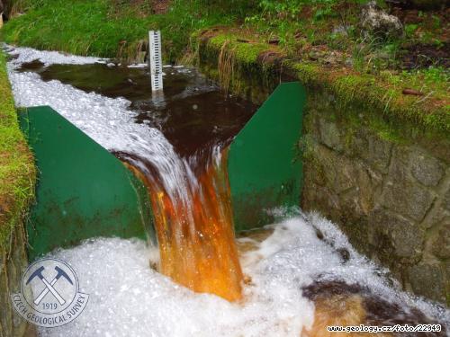
Troughflow is continuously measured in the closure profile (Fig. 2a, b). The catchment is equipped with the data telemetry trough mobile networks (GPRS) that facilitates the preservation of measuring continuity. The possibility to monitor the running results eliminates the risk of loss of data thanks to the early detection of eg. incorrect function of sensors.
|
|

Fig. 2a: Specific spillway at Lysina catchment - flood.
(Author: Pavel Krám)
|
|

Fig. 2b: Specific spillway at Lysina catchment - dry.
(Author: Pavel Krám)
|
|
All catchments are equipped with cumulative samplers of precipitation in an open area and with canopy troughfall samplers that simultaneously serve to the determination of total monthly precipitation. Mixed sample from nine, or five, troughfall precipitation samplers represents well the distributioon of troughfall precipitation due to large variability of vegetation density (Fig. 3).
|
|

Fig. 3 An example of placement of automatic troughfall precipitation samplers at the catchment Liz.
(Author: Tomáš Chuman)
|
|
Following parameters are regularly measured at each catchment: monthly data about components concentration (macro- and trace components Na, Ca, K, Mg, S (SO4), N (NO3, NH4), Cl, F, Mn, Fe, Zn, Al, As,Cd, Pb, Ni), pH and conductivity in the open area precipitation, troughfall precipitation and runoff hydrological data – monthly precipitation totals and daily troughflow calculated flows of components (inputs and outputs from catchment) and balance, i. e. input minus output, which talks about the resulting accumulation (+) or leaching (-) of concrete component organic carbon and organic nitrogen concentrations are newly determined
|
|