Historické mapy
Home (Úvod)
Application Enter
Authors gallery
Project information
Application help
Search
Map sets
Year of publication
Region
Author
Scale
Type
Theme of the map
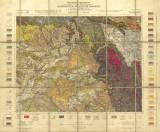
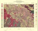
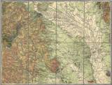
Geological special map of the Kingdom and countries constituting the Austro-Hungarian Empire, (Bohemian and Moravian area), scale 1:75 000
Geological special map of the Kingdom and countries constituting the Austro-Hungarian Empire (1912)
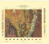
Geological special map of the Kingdom and countries constituting the Austro-Hungarian Empire, Lanškroun a Moravská Třebová (1904)
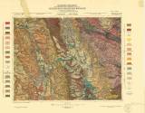
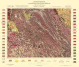
Geological special map of the kingdoms and lands of the Austro-Hungarian Monarchy (1905)
Geological special map of the Kingdom and countries constituting the Austro-Hungarian Empire (1898)
Geological special map of the Kingdom and countries constituting the Austro-Hungarian Empire (1909)
Geological special map of the Kingdom and countries constituting the Austro-Hungarian Empire, Polička a Nové Město na Moravě (1914)
Geological special map of the Kingdom and countries constituting the Austro-Hungarian Empire, Březová nad Svitavou a Jevíčko (1914)
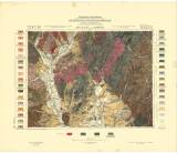
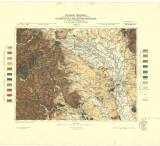
Geological special map of the Kingdom and countries constituting the Austro-Hungarian Empire, Olomouc (1898)
Geological special map of the Kingdom and countries constituting the Austro-Hungarian Empire, Olomouc (1898)
(C) Czech Geological Survey 2004
www.geology.cz