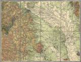
 [Geologische Specialkarte der im Reichsrate vertretenen Königreiche und Länder der Österreichisch-Ungarischen Monarchie] [Geologische Specialkarte der im Reichsrate vertretenen Königreiche und Länder der Österreichisch-Ungarischen Monarchie]Olmütz (der topographischen Specialkarte Zone 7, Col.XVI) (4158) (Geological special map of the Kingdom and countries constituting the Austro-Hungarian Empire) (Olomouc) Author: Tietze, Emil Ernst August Author's comment: mapping campaign 1889-1890 (with use of older materials of M.V. Lipold, H. Wolfa) Country: Czech Republic; Czech Crownlands Document language: German Publisher: K.k. Geologische Reichsanstalt, Wien, first edition presumably the original version of geological map, the map is cut and mounted, legend glued overleaf of the map sheet Year: 1898 Scale: 1 : 75 000 Theme of the map: geological map with Quaternary deposits Type: Map Color: Coloured Form: Loose map Kind: Printed Original source for this digital copy : Czech Geological Survey, Prague Original dimensions: 383 x 498 mm (height x width) |


