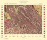
 Geologische Specialkarte der im Reichsrate vertretenen Königreiche und Länder der Österreichisch-Ungarischen Monarchie Geologische Specialkarte der im Reichsrate vertretenen Königreiche und Länder der Österreichisch-Ungarischen MonarchiePolička und Neustadtl (der topographischen Specialkarte Zone 7, Col.XIV) (4156) (Geological special map of the Kingdom and countries constituting the Austro-Hungarian Empire) (Polička and Nové Město na Moravě) Author: Rosiwal, August Author's comment: mapping campaign 1893-1895 (with use of older materials of, F. Foetterle, M.V. Lipold, H. Wolfa, J. Krejčí and R. Helmhacker) Country: Czech Republic; Czech Crownlands Document language: German Publisher: K.k. Geologische Reichsanstalt, Wien, first edition editorial data and legend are glued overleaf of some map sheet copies Year: 1914 Scale: 1 : 75 000 Theme of the map: geological map with Quaternary deposits Type: Map Color: Coloured Form: Loose map Kind: Printed Original source for this digital copy : Czech Geological Survey, Prague Original dimensions: 383 x 498 mm (height x width) |


