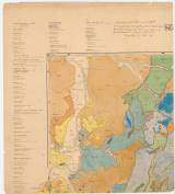
 Selmeczi bányavidék átnézeti térképe a telerek vonulataival Selmeczi bányavidék átnézeti térképe a telerek vonulataival(General map of the environs of Banská Štiavnica with ore veins ) Authors: Szábó, József; Cseh, Ĺudovit; Gesell, Alexandr Author's comment: Drawn by Adolf Bielik Country: Hungary; Slovakia; Austria-Hungary Document language: French, Hungarian, German Publisher: publisher not specified, first edition Year: 1884 Scale: 1 : 14 400 Theme of the map: geological map with Quaternary deposits, map of mineral deposits Type: Map Color: Coloured Form: Set of sequential loose sheets Kind: Printed Original source for this digital copy : HKG – Central Provincial Bureau at Banská Štiavnica HKG 8740- list 1 Original dimensions: 1310 x 1760 mm (height x width) |


