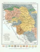
 Geognostische Karte des Egerer Bezirkes Geognostische Karte des Egerer Bezirkesauf Grundlage der Kreybich'schen Karte entworfen von Professor Dr. Reuss 1850 (Geological map of the Cheb district) (compiled in 1850 by Prof.dr.Reuss on the basis of a map by Kreybich) Author: Reuss, August Emanuel Author's comment: Lithography and typography by K.k. Hof-und Staatsdruckerei Country: Czech Republic; Czech Crownlands Document language: German Publisher: K.k. Geologische Reichsanstalt, Wien, first edition Supplement to a paper by A.E. Reuss: Die geognostischen Verhältnisse des Egerer Bezirkes und des Ascher Gebietes in Böhmen, published in "Abhandlungen der k.k. geologischen Reichsanstalt", vol. 1. Wien 1852 Year: 1852 Scale: 1 : 172 800 Theme of the map: geological map with Quaternary deposits Type: Map supplement Color: Coloured Form: Bound appendix Kind: Printed Original source for this digital copy : National Library of the Czech Republic, Prague Original dimensions: 228 x 200 mm (height x width) |


