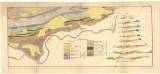
 Geologische Karte eines Theiles des südlichen Randes der obern Abtheilung der Silurformation in Böhmen Geologische Karte eines Theiles des südlichen Randes der obern Abtheilung der Silurformation in Böhmen[Tab. I. b.] (Geological map of a part of southern margin of the Late Silurian in Bohemia [Radotín] ) Authors: Lipold, Marcus Vincenz; Krejčí, Jan Author's comment: Country: Czech Republic; Czech Crownlands Document language: German Publisher: Kaiserlich-königliche Geologische Reichsanstalt, Wien, first edition Supplement (Table Ib) to a paper by M.V.Lipold: Über Herrn J. Barrande's, Colonien' in der Silur-Formation Böhmens, published in "Jahrbuch der k.k. geologischen Reichsanstalt", vol. 12, No. 1. Wien 1861 Year: 1861 Scale: 1 : 28 800 Theme of the map: geological map with Quaternary deposits Type: Map supplement Color: Black and white Form: Bound appendix Kind: Printed Original source for this digital copy : Czech Geological Survey, Prague , Czech Geological Survey, Prague Original dimensions: 197 x 478 mm (height x width) |


