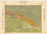
 Geologische Spezialkarte der im Reichsrate vertretenen Königreiche und Länder der Österreichisch-Ungarischen Monarchie Geologische Spezialkarte der im Reichsrate vertretenen Königreiche und Länder der Österreichisch-Ungarischen MonarchieZone 8 Kol XXIII Alt-Lublau und Szczawnica NG-Gruppe Nr. 55 [4265] (Geological special map of the kindom and countries constituting the Austro-Hungarian Empire) (Stará Ľubovňa and Szczawnica) Author: Uhlig, Viktor (W.) Author's comment: an older geological mapping at the scale 1:144,000 by G. Stach, M. Neumayer 1868, reambulation to the scale 1:75,000 by V. Uhlig 1884–1885 Country: Poland; Slovakia; Austria-Hungary Document language: German Publisher: K.k. Geologische Reichsanstalt, Wien Geological special map of the kindom and countries constituting the Austro-Hungarian Empire with geological setting. Year: 1885? Scale: 1 : 75 000 Theme of the map: geological map with Quaternary deposits Type: Map Color: Coloured Form: Loose map Kind: Printed Original source for this digital copy : HKG – Central Provincial Bureau at Banská Štiavnica HKG 10003 |


