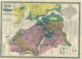
 Plan von Karlsbad und dessen Umgebung Plan von Karlsbad und dessen Umgebung(City map of Karlovy vary and its environs ) Author: Hochstetter, Ferdinand Author's comment: Drawn by Jos. Micoletzky Country: Czech Republic; Czech Crownlands Document language: German Publisher: Verlag von Franieck, Karlovy Vary Supplement to the book by F. Hochstetter:Karlsbad, seine geognostischen Verhältnisse und seine Quellen, Karlovy Vary 1856. The map was again published separately in (1873) Year: 1855 Scale: 1 : 11 520 Theme of the map: geological map with Quaternary deposits Type: Map Color: Coloured Form: Folded map Kind: Printed Original source for this digital copy : National Library of the Czech Republic, Prague Original dimensions: 511 x 719 mm (height x width) |


