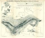
 Die Kohlenfelder und Faltengebirge Mitteleuropas nach Schluss der Carbonzeit Die Kohlenfelder und Faltengebirge Mitteleuropas nach Schluss der Carbonzeit(Coal basins and folded chains of central Europe at the end Carboniferous period) Author: Frech, Fritz Author's comment: Drawn by Dr. Loeschmann Country: Czech Republic; Czech Crownlands; Central Europe Document language: German Publisher: E. Schweizerbart'sche Verlagshandlung und Druckerei, Stuttgart, first edition Supplement to the book by F. Frech: Lethaea geognostica oder Beschreibung und Abbildung der für die Gebirgs-Formationen bezeichnendsten Versteinerungen. Teil I - Letaea palaezoica. 2. Band. 2. Lieferung. Die Steinkohlenformation Year: 1899 Scale: 1 : 3 000 000 Theme of the map: map of mineral deposits Type: Map supplement Color: In one colour Form: Bound appendix Kind: Printed Original source for this digital copy : National Library of the Czech Republic, Prague Original dimensions: 388 x 474 mm (height x width) |


