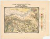
 Esztergom barnaszénterületének földtani térképe Esztergom barnaszénterületének földtani térképe(Geological map of the Ezstergom (Ostřihom) coal district) Author: Hantken, Maximilián [Miksától] Country: Slovakia; Austria-Hungary Document language: Hungarian, Slovak Publisher: publisher not specified, first edition Possible period of origin: the begin of 20 century Year: Theme of the map: geological map with Quaternary deposits, mining map Type: Map Color: Coloured Form: Loose map Kind: Printed Original source for this digital copy : HKG – Central Provincial Bureau at Banská Štiavnica HKG 10006 Original dimensions: 500 x 620 mm (height x width) |


