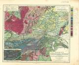
 Franz Foetterle's Geologischer Atlas des Österreichischen Kaiserstaats… Erste Lieferung Franz Foetterle's Geologischer Atlas des Österreichischen Kaiserstaats… Erste LieferungGeologische Karte des Erzherzogthumes Österreich unter der Enns (F.Foetterle’s Geological atlas of the Austrian Kingdom) (Geological map of the Archduchy of Lower Austria) Author: Foetterle, Franz Author's comment: Based on studies of Imperial Geol.Survey, Styrian Geological Mining Association in Graz and Werner’s Society in Brno Country: Austria; Czech Republic; Czech Crownlands Document language: German Publisher: Justus Perthes, Gotha, first edition The map includes parts of southern Bohemia and southern Moravia roughly from 49th parallel of latitude to the south Year: 1860 Scale: 1 : 750 000 Theme of the map: geological map with Quaternary deposits Type: Map Color: Coloured Form: Bound atlas Kind: Printed Original source for this digital copy : Map collection of Charles University, Prague Original dimensions: 317 x 366 mm (height x width) |


