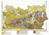
 [Geologická mapa Markrabství Moravského a Vévodství Slezského] [Geologická mapa Markrabství Moravského a Vévodství Slezského][list 6] ([Geological map of the Markgraviate of Moravia and the Duchy of Silesia]) (Map sheet 6 ) Author: Foetterle, Franz Author's comment: In charge of mapping project – Franz Foetterle Country: Czech Republic; Poland; Czech Crownlands Document language: German Publisher: K.k. Militärisches Geographisches Institut, Wien, first edition Colored geological situation plotted at the turn of the fifties and sixties of the 19th century in printed tographic map of 1844, two versions of drawings in some copies Year: Scale: 1 : 144 000 Theme of the map: geological map with Quaternary deposits Type: Map Color: Coloured Form: Set of sequential loose sheets Kind: Photo copy Original source for this digital copy : Czech Geological Survey, Prague Original dimensions: 269 x 392 mm (height x width) |