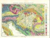
 Rakousko-Uhersko, mapa geologická Rakousko-Uhersko, mapa geologická(Austria-Hungary, geological map ) Author: Procházka, Vladimír Josef Country: Czech Republic; Austria-Hungary; Bosnia; Herzegovina; Montenegro Document language: Czech Publisher: J. Otto, Prague, first edition Published twice or in two mutations – 1) as a part of the Otta geographic atlas (no. 13) with the title probably from the year 1923, mentioned in the heading and/or 2) with the title "Přehledná geologická mapa mocnářství Rakousko-uherského a sousedních zemí" (Synoptic geological map of the Austro-Hungarian Monarchy and adjacent countries) Year: Scale: 1 : 2 750 000 Theme of the map: geological map with Quaternary deposits Type: Map Color: Coloured Form: Folded map Kind: Printed Original source for this digital copy : Czech Geological Survey, Prague Original dimensions: 369 x 484 mm (height x width) |


