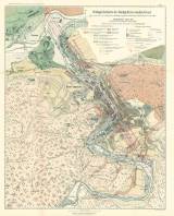
 Geologische Karte des Stadtgebietes von Karlsbad Geologische Karte des Stadtgebietes von Karlsbadaufgenommen 1887-8 auf Grundlage des vom Stadtbauamte revidirten Schindler'schen Situationsplanes vom Jahre 1885 (Geological map of the Karlovy Vary area) (Compiled in 1887-8 according to Schindler’s scheme of 1885) Authors: Rosiwal, August; Teller, Friedrich Author's comment: Location of springs and thermal zone was demarcated by Aug.Rosiwal; typographer Th. Bannwarth, Vienna Country: Czech Republic; Czech Crownlands Document language: German Publisher: K.k. Geologische Reichsanstalt, Wien, first edition Supplement (Figure XIV) to a paper by A. Rosiwal: Ueber neue Massnahmen zum Schutze der Karlsbader Thermen, published in "Jahrbuch der Kaiserlich-Königlichen Geologischen Reichsanstalt", Band XLIV, 1894, Wien Year: 1895 Scale: 1 : 4 000 Theme of the map: geological map with Quaternary deposits Type: Map supplement Color: Coloured Form: Bound appendix Kind: Printed Original source for this digital copy : Czech Geological Survey, Prague |


