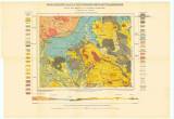
 Geologische Karte des böhmischen Mittelgebirges Geologische Karte des böhmischen MittelgebirgesBlatt XIII. Umgebung von Gartitz und Tellnitz (Geological map of České středohoří Mountains) (Map sheet XIII. The environs of Skorotice-Ždírnice ) Author: Seemann, Fritz Country: Czech Republic; Czech Crownlands Document language: German Publisher: Alfred Hölder, Wien, first edition Published in "Tschermarks mineralogische und petrographische Mitteilungen. Neue Fogle", vol. 33. Wien 1914 Year: 1914 Scale: 1 : 25 000 Theme of the map: geological map with Quaternary deposits Type: Map Color: Coloured Form: Loose map Kind: Printed Original source for this digital copy : Czech Geological Survey, Prague Original dimensions: 296 x 372 mm (height x width) |


