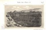
 [Mapa okolí Svárovského a Nučického mezi Prahou a Berounem] [Mapa okolí Svárovského a Nučického mezi Prahou a Berounem]Rudní lom u Nučic č. II (A map of the environs of Svárov and Nučice between Prague and Beroun) (Opencast mine near Nučice No.II ) Authors: Helmhacker, Rudolf; Vála, Josef Author's comment: Lithography by Friedr. Sandtner, Prag Country: Czech Republic; Czech Crownlands Document language: Czech Publisher: Fr. Řivnáč (commission publisher), Prague, first edition Supplement (Figure 5) to a paper by Vál-Helmhacker: Iron ores in the area between Prague and Beroun, published in "Archiv pro přírodovědecké proskoumání Čech", vol.2. No.1, 1877 Year: 1877 Scale: 1 : 288 000 Theme of the map: geological map without Quaternary deposits Type: Graphic insert Color: Black and white Form: Bound appendix Kind: Printed Original source for this digital copy : Czech Geological Survey, Prague |
| Other variety of this document |


