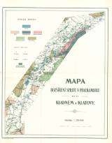
 Mapa rozšíření spilitů v praekambriu mezi Kladnem a Klatovy Mapa rozšíření spilitů v praekambriu mezi Kladnem a Klatovy(A map of spilite distribution in the Precambrian between Kladno and Klatovy ) Author: Slavík, František Country: Czech Republic; Czech Crownlands Document language: German Publisher: Fr. Řivnáč (commission publisher), Prague, first edition Supplement to a paper by F.Slavík: Spilite volcanics in the Precambrian between Kladno and Klatovy, published simultaneously in Czech and German version in edition "Archiv pro přírodovědecký výzkum Čech (Archiv der naturwissenschaftlichen Landesdurchforschung von Böhmen)", vol. XIV/2 Year: 1908 Scale: 1 : 200 000 Theme of the map: geological map without Quaternary deposits Type: Map Color: Coloured Form: Bound appendix Kind: Printed Original source for this digital copy : Czech Geological Survey, Prague Original dimensions: 442 x 356 mm (height x width) |


