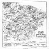
 Nástin tektonické mapy západní části Třemošenského pohoří mezi Strašicemi a Rokycany Nástin tektonické mapy západní části Třemošenského pohoří mezi Strašicemi a Rokycany(Tectonic sketch map of western part of Třemošná highland between Strašice and Rokycany ) Author: Purkyně, Cyril Author's comment: Lithography Farský, Prague Country: Czech Republic; Czech Crownlands Document language: Czech Publisher: Čes. akad. cís. Františka Josefa pro vědy, slovesnost a umění, Prague, first edition Supplement to the paper: Tectonic scheme of the Třemošná highland between Strašice and Rokycany, published in "Rozpravy České akademie císaře Františka Josefa pro vědy, slovesnost a umění, Třída II, vol. XXIV, No. 34. Praha 1915 Year: 1915 Scale: 1 : 50 000 Theme of the map: tectonic map, geological map without Quaternary deposits Type: Map supplement Color: Black and white Form: Bound appendix Kind: Printed Original source for this digital copy : Czech Geological Survey, Prague Original dimensions: 211 x 206 mm (height x width) |


