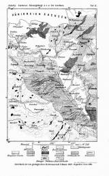
 [Geologická mapa západního okolí Liberce, oblasti Ještědu a části Lužických hor] [Geologická mapa západního okolí Liberce, oblasti Ještědu a části Lužických hor](Geological map of western environs of Liberec, Ještěd area and part of Lužické hory Mountains ) Author: Jokély, Johann Author's comment: Lithography by Hof-und Staatsdruckerei, Wien Country: Czech Republic; Czech Crownlands Document language: German Publisher: K.k. Geologische Reichsanstalt, Wien, first edition Supplement (Table 9) to a paper by J. Jokély: Der nordwestliche Theil des Riesengebirges, und das Gebirge von Rumburk und Hainspach in Böhmen, published in "Jahrbuch der k.k. Geologischen Reichsanstalt", vol. 10, No. Wien 1859 Year: 1859 Scale: 1 : 144 000 Theme of the map: geological map with Quaternary deposits Type: Map supplement Color: Black and white Form: Bound supplement Kind: Printed Original source for this digital copy : Czech Geological Survey, Prague Original dimensions: 172 x 117 mm (height x width) |


