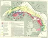
 Tektonische Kartenskizze der Karpaten Tektonische Kartenskizze der Karpaten(Tectonic sketch map of Carpathians ) Author: Uhlig, Viktor (W.) Author's comment: Lithography and typography by Wagner&Debes, Leipzig Country: Czech Republic; Hungary; Poland; Slovakia; Czech Crownlands Document language: German Publisher: F. Tempsky, G. Freytag, Wien, Leipzig, first edition Supplement to the book: Bau und Bild Österreichs, to its 3rd part by V. Uhlig: Bau und Bild der Katpaten. Wien-Leipzig 1903 Year: 1903 Scale: 1 : 1 500 000 Theme of the map: tectonic map, geological map with Quaternary deposits Type: Map supplement Color: Coloured Form: Bound appendix Kind: Printed Original source for this digital copy : Czech Geological Survey, Prague Original dimensions: 477 x 603 mm (height x width) |


