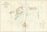
 Karte der kohlenführenden Gebirgsformationen von Böhmen Karte der kohlenführenden Gebirgsformationen von Böhmen(Map of coal-bearing petrographic formations of Bohemia) Author: Zippe, František Xaver Maximilian Author's comment: Drawn by Kočzy Country: Czech Republic; Czech Crownlands Document language: German Publisher: Verlag des Vereines zur Ermunterung des Gewerbegeistes in Böhmen, Prague, first edition Suplement to a paper by F.X.M.Zippe: Die Steinkohlen, ihr Werth und ihre Wichtigkeit im Allgemeinen und ihre Verbreitung in Böhmen, published in "Encyclopädische Zeitschrift des Gewerbewesens", Praha 1842 Year: 1842 Scale: 1 : 1 200 000 Theme of the map: map of mineral deposits, petrographical map Type: Map supplement Color: Coloured Form: Bound appendix Kind: Printed Original source for this digital copy : Library of the Faculty of Science, Charles University, Prague Original dimensions: 282 x 431 mm (height x width) |


