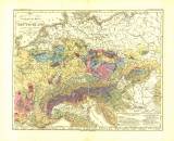
 Geologische Karte von Deütschland und den anlieg. Ländern Geologische Karte von Deütschland und den anlieg. Ländern(Geological map of Germany and adjacent countries) Author: Credner, Hermann Country: Czech Republic; Czech Crownlands Document language: German Publisher: Justus Perthes, Gotha, second edition Map sheet from Berghaus' Physikal. Atlas, 3.Abtheilung. Geologie No.12 Year: 1850 Scale: 1 : 4 700 000 Theme of the map: geological map with Quaternary deposits Type: Map Color: Coloured Form: Loose map Kind: Printed Original source for this digital copy : private collection of Dr.J.Kozák Original dimensions: 290 x 355 mm (height x width) |


