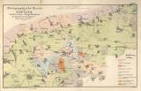
 Petrographische Karte von Teplitz und seinen Umgebungen. (Taf.V) Petrographische Karte von Teplitz und seinen Umgebungen. (Taf.V)(Petrographic map of Teplice and its environs) Author: Reuss, August Emanuel Author's comment: Printed by Herwig Country: Czech Republic; Czech Crownlands Document language: German Publisher: publisher not specified, first edition Supplement (Table V) published in Archiv für Mineral.Geogn. Bergbau u. Hüttenk., Bd.XI, Heft 2 (Berlin 1838?) Year: 1838? Scale: 1 : 50 000 Theme of the map: petrographical map Type: Map Color: Coloured Form: Loose map Kind: Printed Original source for this digital copy : private collection of Dr.J.Kozák Original dimensions: 208 x 337 mm (height x width) |


