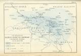
 Rozšíření a stupně síly zemětřesení v severovýchodních Čechách Rozšíření a stupně síly zemětřesení v severovýchodních Čecháchdne 10. ledna 1901 (Distribution and degree of earthquake strenght in northeastern Bohemia) (On January 10, 1901) Author: Woldřich, Jan Nepomuk Country: Czech Republic; Czech Crownlands Document language: Czech Publisher: F. Bačkovský, Prague, first edition Part of three-part publication by J.N.Woldřich: General geology with special emphasis on Crown Lands of Bohemia (First part – Physiographic geology, Second part- Dynamic geology, Third part: Historical geology) 1902, 1905, Praha, publisher F. Bačkovský Year: 1902 Scale: 1 : 2 186 000 Theme of the map: earthquake map Type: Map Color: Coloured Form: Bound supplement Kind: Printed Original source for this digital copy : Czech Geological Survey, Prague Original dimensions: 137 x 200 mm (height x width) |


