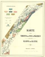
 Karte der Verbreitung der Spilite im Präkambrium zwischen Kladno und Klattau Karte der Verbreitung der Spilite im Präkambrium zwischen Kladno und Klattau(Map of distribution of spilites in the Precambrian System between Kladno and Klatovy ) Author: Slavík, František Country: Czech Republic; Czech Crownlands Document language: German Publisher: Fr. Řivnáč (commission publisher), Prague, first edition Supplement to a paper F. Slavík: Spilit.Ergussgesteine im Präkambrium zwischen Kladno u.Klattau, published in Czech and German versions in edition "Archiv pro přírodověd.prozkoumání Čech edition "Archiv pro přírodovědecký výzkum Čech/Archive for scientific research of Bohemia /Archiv für die Landesdurchforschung von Böhmen", XIV/2 Year: 1908 Scale: 1 : 200 000 Theme of the map: geological map without Quaternary deposits Type: Map Color: Coloured Form: Bound appendix Kind: Printed Original source for this digital copy : Czech Geological Survey, Prague Original dimensions: 442 x 356 mm (height x width) |


