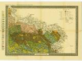
 Prozkoumání Čech. Sekce III Prozkoumání Čech. Sekce IIIGeologická mapa. [Okolí Železného Brodu a Jičína až k Broumovu a Náchodu] (Exploration of Bohemia. Section III ) (Geological map [the environs of Železný Brod and Jičín as far as Broumov and Náchod]) Authors: Frič, Antonín; Laube, Gustav Country: Czech Republic; Czech Crownlands Document language: Czech Publisher: Komitét pro přírodovědecký výzkum Čech, b.m., first edition Map published together with explanatory notes in Czech and German versions in edition " Archiv pro přírodovědecký výzkum Čech" (Archiv für die naturwissenschaftliche Landesdurchforschung von Böhmen), vol.IX/1, No.6 Year: 1896 Scale: 1 : 200 000 Theme of the map: geological map with Quaternary deposits Type: Map Color: Coloured Form: Loose map Kind: Printed Original source for this digital copy : Czech Geological Survey, Prague Original dimensions: 404 x 583 mm (height x width) |


