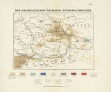
 Das Oberschlesisch-polnische Steinkohlenbecken Das Oberschlesisch-polnische Steinkohlenbecken(Upper Silesian-Polish black coal basin ) Author: Roemer, Ferdinand Author's comment: Print M.Spiegel, Breslau Country: Austria; Czech Republic; Czech Crownlands; Prussia; Russia Document language: German Publisher: Robert Nischkowsky, Breslau, first edition Supplement (Table 1) to a paper by F.Roemer : Geologie von Oberschlesien, Breslau (Wróclaw) 1870, part of a separate appendix - Karten und Profile Year: 1870 Scale: 1 : 730 000 Theme of the map: map of mineral deposits Type: Map Color: Coloured Form: Bound appendix Kind: Printed Original source for this digital copy : Czech Geological Survey, Prague Original dimensions: 138 x 191 mm (height x width) |


