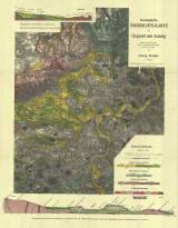
 Geologische Übersichts-Karte der Gegend um Aussig Geologische Übersichts-Karte der Gegend um Aussiggearbeitet nach den Karten der k.k. geologischen Reichsanstalt und des Dr. J. E. Hibsch (Synoptic geological map of the environs of Ústí nad Labem) (compiled according to maps of c.k.Imperial Geological Survey and Dr.J.E.Hibsch ) Author: Bruder, Georg Author's comment: Lithography and printing by E.Rennert, Ústí nad Labem Country: Czech Republic; Czech Crownlands Document language: German Publisher: Adolf Becker, Teplice, first edition Supplement to the book by G. Bruder: Geographische Skizzen aus der Umgebung Aussig, Zweite Abteilung. Ústí nad Labem 1907 Year: 1907 Scale: 1 : 75 000 Theme of the map: geological map with Quaternary deposits Type: Map Color: Coloured Form: Folded map Kind: Printed Original source for this digital copy : Czech Geological Survey, Prague Original dimensions: 452 x 362 mm (height x width) |


