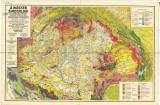
 A Magyar birodalom és a szomszédos országok határos területeinek földtani térképe A Magyar birodalom és a szomszédos országok határos területeinek földtani térképe(Geological map of Hungarian empire and territories of neighbour counties) Author: Lóczy, L'udovid Author's comment: Mapping campaign 1890-1910 Country: Hungary; Slovakia; Czech Crownlands Document language: Hungarian Publisher: Magyar földrajzi társaság, Budapest, second edition According to Kettnerová a map by Lajos Lóczy was published in 1896 (1st edition ?) which extends deeply into the territory of Moravia Year: 1922 Scale: 1 : 900 000 Theme of the map: geological map with Quaternary deposits Type: Map Color: Coloured Form: Loose map Kind: Printed Original source for this digital copy : Czech Geological Survey, Prague Original dimensions: 690 x 1080 mm (height x width) |


