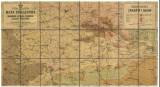
 Geologiczna mapa poglądowa morawsko-szląsko-polskiego zaglębia węglowego Geologiczna mapa poglądowa morawsko-szląsko-polskiego zaglębia węglowego(Synoptic geological map of the Moravia-Silesian-polish coal basin) Author: Bartonec, František Country: Czech Republic; Poland; Czech Crownlands Document language: Polish Publisher: publisher not specified, first edition The map was presumably also published in German version - Geognostische Ubersichtskarte des mahrischen-schlesischen Kohlenreviers, 1894 (Procházka) Year: 1894 Scale: 1 : 225 000 Theme of the map: geological map with Quaternary deposits, map of mineral deposits Type: Map Color: Coloured Form: Loose map Kind: Printed Original source for this digital copy : Czech Geological Survey, Prague Original dimensions: 444 x 809 mm (height x width) |


