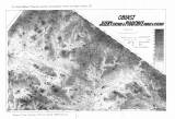
 Oblast Jizery (střední) a Ploučnice (horní a střední) Oblast Jizery (střední) a Ploučnice (horní a střední)Příspěvek k poznání morfologického vývoje české tabule křídové - III. (Area of the river Jizera (middle stretch) and the river Ploučnice (upper and middle)) (Contribution to the knowledge of morphological development of the Bohemian Cretaceous Basin – III.) Author: Dědina, Václav Country: Czech Republic; Czech Crownlands Document language: Czech Publisher: Čes. akad. cís. Františka Josefa pro vědy, slovesnost a umění, Prague, first edition Supplement to a paper by V.Dědina: "Contribution to the knowledge of morphological development of the Bohemian Cretaceous Basin – III., published in "Rozpravy České akademie císaře Františka Josefa pro vědy, slovesnost a umění, Třída II", vol. XXVII, No. 25. Praha 1917 Year: 1917 Scale: 1 : 200 000 Theme of the map: morphological map Type: Map supplement Color: Shades of gray Form: Bound appendix Kind: Printed Original source for this digital copy : Czech Geological Survey, Prague Original dimensions: 197 x 307 mm (height x width) |


