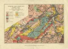
 Geologická mapa krajiny mezi Mníškem a Davlí Geologická mapa krajiny mezi Mníškem a Davlí(Geological map of the area between Mníšek and Davle) Author: Kettner, Radim Author's comment: Litographer V.Štumper, Praha Country: Czech Republic; Czech Crownlands Document language: Czech Publisher: Čes. akad. cís. Františka Josefa pro vědy, slovesnost a umění, Prague, first edition Supplement to a paper by R.Kettnera: About laccolith intrusions of porphyrs between Mníšek and the river Vltava, published in "Rozpravy České akademie císaře Františka Josefa pro vědy, slovesnost a umění, Třída II", vol. XXIII, No. 10. Praha 1914 Year: 1914 Scale: 1 : 48 000 Theme of the map: geological map with Quaternary deposits Type: Map supplement Color: Coloured Form: Bound supplement Kind: Printed Original source for this digital copy : Czech Geological Survey, Prague Original dimensions: 193 x 294 mm (height x width) |


