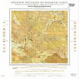
 Geologische Specialkarte des Königreichs Sachsen Geologische Specialkarte des Königreichs SachsenSection Kühnhaide-Sebastiansberg No. 140 (5445) (Geological special map of the Kingdom of Saxony) (Section Kühnhaide-Hora Sv.Šebestiána No.140 (5445)) Author: Hazard, J. Author's comment: Mapping campaign 1886 Country: Czech Republic; Czech Crownlands; Saxony; Austria-Hungary; Germany Document language: German Publisher: Königliche Finanz-Ministerium, Leipzig, first edition reprint – added new numerical index 5445 Year: 1887 Scale: 1 : 25 000 Theme of the map: geological map with Quaternary deposits Type: Map Color: Coloured Form: Loose map Kind: Printed Original source for this digital copy : Czech Geological Survey, Prague Original dimensions: 475 x 500 mm (height x width) |


