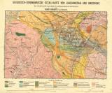
 Geologisch-bergmännische Detail-Karte von Joachimsthal und Umgebung Geologisch-bergmännische Detail-Karte von Joachimsthal und UmgebungDas Schiefergebiet geologisch aufgenommen und kartirt (Detailed geological and mining map of Jáchymov and the environs) (Geological sampling and mapping of slate region) Author: Babanek, Franz Author's comment: The quoted paper in the publication: Geologisch-bergmännische Karte mit Profilen von Joachimsthal nebst Bildern von den Erzgängen in Joachimsthal und von den Kupferkies-Lagerstätten bei Kitzbühel (edit. F. M. Ritter von Friese and W. Göbl) Country: Czech Republic; Czech Crownlands Document language: German Publisher: b.v., Wien, first edition On the paper by F. Babanek: Beschreibung der geologisch-bergmännischen Verhältnisse der Joachimsthaler Erzlagerstätten, Wien 1891 Year: 1889 Scale: 1 : 25 000 Theme of the map: geological map without Quaternary deposits Type: Map Color: Coloured Form: Loose map Kind: Printed Original source for this digital copy : Czech Geological Survey, Prague Original dimensions: 290 x 434 mm (height x width) |


