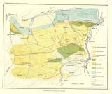
 [Geologická mapa severozápadního okolí Jinců] [Geologická mapa severozápadního okolí Jinců](Geological map of NW environs of Jince (Central Bohemia)) Author: Liebus, Adalbert Author's comment: Lithography and typography by Th. Bannwarth, Wien Country: Czech Republic; Czech Crownlands Document language: German Publisher: Kaiserlich-königliche Geologische Reichsanstalt, Wien, first edition Supplement (Table 5) to a paper by A. Liebus: Die Bruchlinie des "Vostry" im Bereiche der SW-sektion des Kartenblattes Zone 6, Kol.X, und ihre Umgebung, published in "Jahrbuch der k.k. geologischen Reichsanstalt", vol. 60. Wien 1910 Year: 1910 Scale: 1 : 25 000 Theme of the map: geological map without Quaternary deposits Type: Map supplement Color: Coloured Form: Bound appendix Kind: Printed Original source for this digital copy : Czech Geological Survey, Prague Original dimensions: 292 x 359 mm (height x width) |


