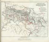
 Verbreitungs-Karte des Erdbebens von Trautenau am 31. Jänner 1883 Verbreitungs-Karte des Erdbebens von Trautenau am 31. Jänner 1883(A map showing distribution of the Trutnov earthquake swarm of January 31, 1883) Author: Laube, Gustav Country: Czech Republic; Czech Crownlands Document language: German Publisher: Kaiserlich-königliche Geologische Reichsanstalt, Wien, first edition Supplement (Table 3) to a paper by Gustav C.Laube: Das Erdbeben von Trautenau am 31. Jänner 1883, published in"Jahrbuch der k.k. geologischen Reichsanstalt", vol.33. Wien 1883 Year: 1883 Scale: 1 : 432 000 Theme of the map: earthquake map Type: Map supplement Color: Two-coloured Form: Bound appendix Kind: Printed Original source for this digital copy : Czech Geological Survey, Prague Original dimensions: 198 x 272 mm (height x width) |


