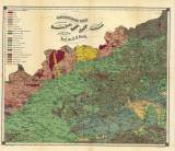
 Geognostische Karte der Gegend zwischen Kommotau, Saaz, Raudnitz & Tetschen Geognostische Karte der Gegend zwischen Kommotau, Saaz, Raudnitz & Tetschen(Geognostic map of the area between Chomutov, Žatec, Roudnice and Děčín) Author: Reuss, August Emanuel Author's comment: Lithography by Mittag.&Wildner, Praha Country: Czech Republic; Czech Crownlands Document language: German Publisher: H. Dominicus, Prague, first edition Supplement to the book by August Emanuel Reuss: Die Geologie des Böhmischen Mittelgebirges Year: 1867? Scale: 1 : 144 000 Theme of the map: geological map with Quaternary deposits Type: Map Color: Coloured Form: Bound appendix Kind: Printed Original source for this digital copy : Czech Geological Survey, Prague Original dimensions: 400 x 480 mm (height x width) |


