|
The Project "Digital map archive of the Czech Geological Survey"
The contemporary way of archiving map documentation in the Archive of the Czech Geological Survey and its granting to public is based on ordinary loan services. It is needless to say that any manipulation with maps and their supplements has a negative influence on the condition of archive maps. There are approximately 60 thousand maps in the Archive, many of them with historical value (maps originated before 1918), some maps are even irreplaceable (author originals).
The works on the project "the Digital map archive of the Czech Geological Survey" were successfully initiated at the end of 2000. The submitter of the project is the Ministry of the Environment - Department of Geology and the main project participant is the Czech Geological Survey. The project is scheduled to finished toward the end of the year 2004.
The principal project objective
The chief objective of hereof project is the long-time and secure preservation of valuable map documentation and easy access to information stored in the Archive of the Czech Geological Survey for scientific and lay community at the same time. The implementation of this intention includes four principal aims:
- Preliminary:
- Complex audit of the maps & documents stored in the Archive
- Setting up a digital workplace including installation of HW & SW
- Creation of the logical data model of document database
- Creation of db applications for registration, monitoring, administration and storing of data
- Creation & testing of scanning parameters 'profiles' (colour depth, dpi, data format etc.)
- Digitalisation of maps and appendices:
- Development of detail workflow - creation of user manuals
- Training of personnel
- Quality control mechanisms
- Tuning of db applications
- Storing of data / backup strategy
- Data integration into the IS of the CGS respectively IS (Oracle):
- Establishing an application for data conversion into RDBMS Oracle (the central data warehouse)
- Establishing a data review application to cover data consistency
- Creation of the web site databases applications:
- Creation of a www presentation of "maps coverage"
- Creation of thematic DVDs/CDs
- Developing a user application for use of the archive of CGS
Process Methodology
Preliminary
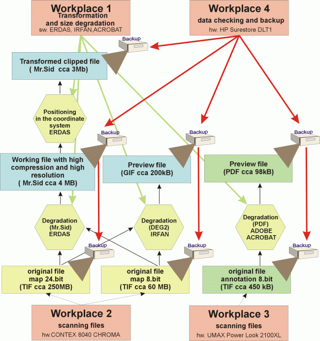
The total number of indvidual map documents and signatures and their placement (Praha-Klarov, Lužná u Rakovníka - Kostelní) were specified after a detailed analysis of the whole map collection completed at the beginning of 2001. Additionally, the documents with problematic scanning characteristics were discovered and described. This detailed review showed the way for the further progress of the digital map collection. The digitalization process was completely revised and bar code technology was recommended. This technology is used in the new administration system, especially for registration. In the future, bar codes will help with authorization procedures.
In the first half of 2001, old garage space was reconstructed and a new digitalization workspace with its HW/SW platform was set up. The workspace is divided into three sections according to its work functions:
- Section for documents preparation and editing
It is the place for complex audit and completing documents with their bibliographic registration while the procces of the data warehouse administration, additionally bar codes are classified. If there are any duplicates they are registered but only the best quality maps are selected to scan. This section includes three workstations.
- Digitalization section
It is devided into three individual workstations equipped with professional scanners. Maps and all documents bigger than format A3 are digitalized. For scanning maps, the scanner CONTEX CHROMA 8040 was chosen. For scanning map supplements, the scanner UMAX Power 1ook 150 is used. Explanatory notes are digitalized with the aid of the HP scanner.
- Data archiving section
All data is saved on 40 GB DLT tapes (with compression up to 80 GB).
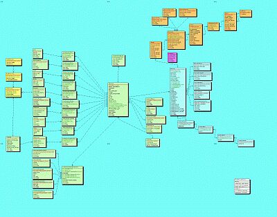
At first it was necessary to create the logical structure for the Digital Map Archive database before the process of digitalization. The applications enabling the registration and preparation of maps, and further easy monitoring of digital documents while the digitalization process were developed. The logical structure of the database was based on the existing Archive's database.
|
|
|
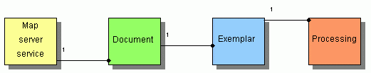
The System of applications of the Integrated Digital Map Collection of the CGS:
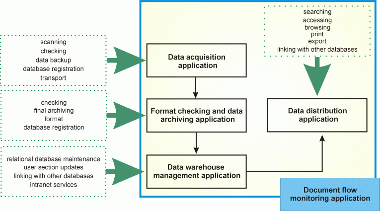
The application for monitoring of documents circulation is divided into five parts. While working in the preliminary time period in 2001 we were focused on establishing the first four system components:
|
- Data acquisition application
- Format checking and data archiving application (Almanach)
- Data warehouse management application
- Document flow monitoring application
|
|
During 2002 some of the applications were modified and the fifth component was added into the system:
|
- Data distribution application
|
|
All components work above the uniform database and are constituents of the system for incorporating scanned data into the subsystem IS CGS:
|
|
Digitalization process
Due to the huge data volume determined for scanning (about 200 000) we found it necessary to elaborate a detailed process description and establish a quality check out mechanism. In 2001 during the "preoperation digitalization status" we tuned out the technical scanning parameters. It was clear from the beggining that each digital document would exist in three qualitatively different versions according to its use - the own data copies are the highest quality (format 1), the middle quality copies for a digital studying room (format 2), and for the Internet presentation are used the lowest-quality copies (format 3). The format 2 was generated using MrSID data compression technology. The full digitalization process started at the beginning of 2002 and so far 20 000 map documents have been scanned.
|
|
|
Data transformation and circulation control of the digitalized documents between the editing and digitalization sections proceed with the aid of the transformation application. Outputs are printed protocols which are directly archived and enable easy control of the transformed documents.
For data archiving, the 40/80 GB DLT tapes were chosen. Information about type of archiving and a tape identificator are supplied into the digital map archive database with the aid of the "Almanach" application. Not only are the three qualitatively different versions saved but also the interproducts. Formats 1 and 2 are stored on the central data server of the CGS (the warehouse). This way of data storing enables an on-line data access, while data safety copies are created at the same time.
After the data is saved on the tape and the printed protocols are archived, the digital documents containing the whole record are registered in the central information system (IS CGS) by the special application which moves data from the register database into the central warehouse.
Data integration into the IS CGS and developing of www data applications
This year besides the scanned data integration process into the IS CGS, we started to work on the internet data applications. At present there are several applications available on the information portal of CGS www.geology.cz. This on-line data access is a presentation and distribution of geological data at once.
List of the Internet presentations:
|
- Map coverage - map grid selection system
- Map coverage - spatial properties selection system
- Map coverage - requesting the RDBMS (non-graphic)
- The first version of GIS map server of CGS
|
|
The technical solution of this partial project goes together with the other projects of the devision of Informatics CGS. Specifically, the creation of a www map server will follow the technologic processes and solutions of these internal projects of CGS:
|
- Establishing a core for the map server of CGS - project number (p.num) CGS 3404
- Progressing the www information portal of CGS- p.num. CGS 3403
- Data sources of CGS - progress, management and use - p.num. CGS 3405
- The methodology, establishment and publication progress of GIS data in CGS - p.num. CGS 3406
|
|
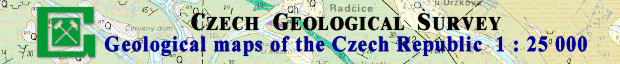
CD/DVD ROM - Interactive Geological Maps of the Czech Republic
This application is the first example of a thematic HTML application which takes advantage of the Digital Archive of the CGS. It is a collection of all geological maps stored in the digital archive of the CGS (printed and author originals) and their entire supplements (graphic attachments and explanatory notes) at the scale of 1 : 25 000 in such grid systems as S-JTSK and S42.
WWW application, on-line access, thematic CD/DVD ROMs, digital studying room and etc., all these together support the idea of minimizing of phyzical manipulation with maps. documents. that a client or visitor of the Archive of CGS wouldn´t even see an original map document. This is the only way to ensure safe storage for map documents and to provide easy access to these map collections for scientific and lay community.
Mgr. Robert Tomas - Project Leader
|