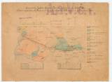
 Geognostische Karte der Gegend Kremnitz aufgenommen von Joh. Pettko Geognostische Karte der Gegend Kremnitz aufgenommen von Joh. Pettko(Nebst angedeuteten K. Ferdinand Ergstollens Betrieb v. J. Tirscher m. p. Praktikant 1868) (Geological map of the environs of Kremnice ) ((The course of drainage adit Ferdinand was plotted by trainee Jozef Tirscher in 1868 on a map compiled on the basis of surveying done by Ján Petka)) Authors: Petko, Ján; Tirscher, Jószef Country: Slovakia; Austria-Hungary Document language: German Publisher: publisher not specified, first edition Year: 1868 Scale: 1 : 72 200 Theme of the map: geological map with Quaternary deposits Type: Map Color: Coloured Form: Loose map Kind: manuscript Original source for this digital copy : State Central Mining Archive at Banska Štiavnica A.a.V.č.1 1111 Original dimensions: 290 x 390 mm (height x width) |


