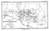
 Die Verbreitung der Glacialspuren im Böhmer-Walde Die Verbreitung der Glacialspuren im Böhmer-Walde(Distribution of glaciation marks in Šumava (Mts) ) Author: Bayberger, Franz Author's comment: Lithography by C. Barich Country: Czech Republic; Czech Crownlands Document language: German Publisher: Justus Perthes, Gotha, first edition Supplement (Figure 1) to a paper by F. Bayberger: Geographisch-geologische Studien aus dem Böhmerwalde. Die Spuren alter Gletscher, die Seen und Thäler des Böhmerwaldes, published as "Ergänzungsheft No 81 zu Petermanns Mitteilungen". Gotha 1886 Year: 1886 Scale: 1 : 600 000 Theme of the map: map of glacial sediments Type: Map supplement Color: Two-coloured Form: Bound appendix Kind: Printed Original source for this digital copy : National Library of the Czech Republic, Prague Original dimensions: 215 x 358 mm (height x width) |


