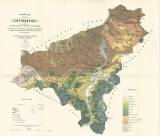
 Přehledná mapa okresu děčínského Přehledná mapa okresu děčínskéhoobsahujíc poměry geologické a rostlinstva hospodarského, jež podle prací E. Bormanna, c.k. geolog. ústavu říšského a výskůmu Čech vedením Prof. Dra. Kořistky navržena a kreslena jest (Synoptic map of the Děčín district ) (Including geological setting and agricultural vegetation which, according to papers by E.Bormann, c.k.Imperial Geological Survey and studies of Bohemia under the leadership of Prof.Dr.Kořistka, were suggested and plotted) Author: Kořistka, Karel Country: Czech Republic; Czech Crownlands Document language: Czech Publisher: Ústřední výbor pro statistiku polního a lesního hospodářství v Čechách, Prague, first edition Supplement to the book by F.C. Dörre and V. Funke: The Děčín district with regard to agriculture and forestry, Praha 1871. According to Roubík a German version of the book with a map has also been published Year: 1871 Scale: 1 : 57 470 Theme of the map: soil map, geological map with Quaternary deposits Type: Map supplement Color: Coloured Form: Bound appendix Kind: Printed Original source for this digital copy : National Library of the Czech Republic, Prague Original dimensions: 425 x 475 mm (height x width) |


