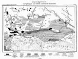
 Geologische Übersichtskarte des Isergebirges und seines nördlichen Vorlandes Geologische Übersichtskarte des Isergebirges und seines nördlichen Vorlandes(Synoptic geological map of the Jizerské hory Moutains and their northern foothills ) Author: Rimann, Eberhard Country: Czech Republic; Czech Crownlands Document language: German Publisher: Königliche Preussische Geologische Landesanstalt, Berlin, first edition Supplement (Fig. 28) to a paper by E. Rimann: Der geologische Bau des Isergebirges und seines nördlichen Vorlandes, published in "Jahrbuch der Königlich Preussischen Geologischen Landesanstalt zu Berlin für Jahr 1910", vol.31, No.1. Berlin 1913 Year: 1913 Scale: 1 : 200 000 Theme of the map: geological map with Quaternary deposits Type: Map supplement Color: Black and white Form: Bound appendix Kind: Printed Original source for this digital copy : National Library of the Czech Republic, Prague Original dimensions: 185 x 289 mm (height x width) |


