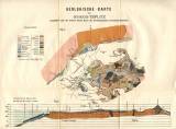
 Geologische Karte von Ossegg-Teplitz Geologische Karte von Ossegg-Teplitzausgeführt nach den Gruben Revier Karte des Nordböhmischen Braunkohlenbeckens (Geological map of Osek-Teplice) (Compiled according to a map of mining district of north Bohemian lignite basin) Author: Löcker, H. Country: Czech Republic; Czech Crownlands Document language: German Publisher: Adolf Becker, Teplice, first edition Supplement (Fig.1) to a paper by H. Löcker: Die Wassereinbrüche in die Dux-Ossegger Kohlengruben, ihre Einwirkung auf die Teplitzer Thermalquellen und ihre Verdämmung, published in the book "Allgemeine Bergmannstag in Teplitz 1899. Festbericht und Verhandlungen. Teplice Year: 1900 Scale: 1 : 75 000 Theme of the map: geological map with Quaternary deposits, mining map Type: Map supplement Color: Coloured Form: Bound appendix Kind: Printed Original source for this digital copy : National Library of the Czech Republic, Prague Original dimensions: 182 x 234 mm (height x width) |


