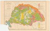
 A magyar állam talaj-térképe A magyar állam talaj-térképe(Soil map of Hungary ) Author: Téglás, Károly Author's comment: Interpretation based on materials by F.Hauer Country: Hungary; Slovakia; Austria-Hungary Document language: Hungarian Publisher: publisher not specified, first edition Possible period of origin: the begin of 20 century Year: Scale: 1 : 2 500 000 Theme of the map: soil map Type: Map Color: Coloured Form: Loose map Kind: Printed Original source for this digital copy : HKG – Central Provincial Bureau at Banská Štiavnica HKG 10004 Original dimensions: 340 x 440 mm (height x width) |


