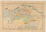
 Carte geológiqe de la chaine du Tatra et des soulévemens parallelles Carte geológiqe de la chaine du Tatra et des soulévemens parallelles(Geological map of Tatra Mountains of their environs ) Author's comment: L. Zejsner, 1844 Country: Slovakia; Austria-Hungary Document language: French Publisher: publisher not specified, first edition Possible period of origin: the end of 19 century Year: Theme of the map: geological map with Quaternary deposits Type: Map Color: Coloured Form: Loose map Kind: Printed Original source for this digital copy : HKG – Central Provincial Bureau at Banská Štiavnica HKG 9994 Original dimensions: 490 x 760 mm (height x width) |


