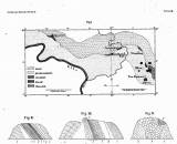
 [Ungefähre Skizze der Grenze von Granit und Quadersandstein von Hohnstein bis Neu-Daubitz mit sämmtlichen an derselben vorkommenden Aufschlüssen von Jurakalk] [Ungefähre Skizze der Grenze von Granit und Quadersandstein von Hohnstein bis Neu-Daubitz mit sämmtlichen an derselben vorkommenden Aufschlüssen von Jurakalk](Rough sketch of the boudary between granite and thick-bedded sandstone between Hohenstein and (Nové) Doubice together will all outcrops of Jurassic limestones in-between) Author: Lenz, Oskar Country: Czech Republic; Czech Crownlands; Saxony; Germany Document language: German Publisher: Wiegandt & Hempel, Berlin, first edition Supplement (Figure 2) to a paper by Oskar Lenz: Über das Auftreten jurassischer Gebilde in Böhmen, published in "Zeitschrift für die gesammten Naturwissenschaften, Neue Folge", vol. 1 (35), Berlin 1870 Year: 1870 Scale: 1 : 200 000 Theme of the map: petrographical map Type: Map supplement Color: Black and white Form: Bound appendix Kind: Printed Original source for this digital copy : Library of the Academy of Sciences of the Czech Republic, Prague Original dimensions: 98 x 190 mm (height x width) |


