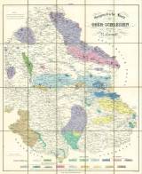
 Geognostische Karte von Ober-Schlesien Geognostische Karte von Ober-Schlesienentworfen von R.von Carnall (Geological map of Upper Silesia ) (designed by R. von Carnall) Author: Carnall, Rudolf von Country: Czech Republic; Poland; Czech Crownlands; Germany Document language: German Publisher: Simon Schropp Co., Berlin, first edition Border zone of Moravian-Silesian region drawn in left lower section of the map Year: 1844 Scale: 1 : 220 000 Theme of the map: petrographical map Type: Map Color: Coloured Form: Folded map Kind: Printed Original source for this digital copy : Map collection of Charles University, Prague Original dimensions: 768 x 621 mm (height x width) |


